Drones: Getting a Birds-Eye View
I was so jealous of birds! As a young child growing up and developing an interest in the natural world, I distinctly remember wishing I could fly. Oh, to see what the birds could see, to go where they could go! I wondered, “what does the world look like to a migrating goose, or a soaring eagle? What can I see from the air that isn’t readily obvious from the ground?
Fast forward several decades, and while I still can’t feel the thrill of actually flying, I can now see what the birds see with the aid of an Unmanned Aerial Vehicle (UAV), more commonly referred to as a drone.
Early this year, our company purchased a “Phantom 4 Pro” UAV. We went through the rigorous licensing procedure with two staff members, became registered with the state and federal governments, and acquired liability insurance. We nicknamed our drone “Ruby”, after the similarities in flight to a Ruby Throated Hummingbird. But Ruby isn’t just a fun toy with a cute name. She’s a workhorse that has enhanced our service capabilities, shortened project times, and given our clients a unique, real time perspective on their property. Equipped with a 20 megapixel camera, her videos and images are crisp and clean. She’s a true professional, and smart to boot. If she gets out of range, she automatically gets back in range or returns to the take-off point. Obstacles are avoided, speed, height, and direction are reported on the dashboard, and several “intelligent” flight modes are available to accomplish unique tasks. The project application possibilities are numerous, but here are just a few ways our drone can be used:
Elevation Maps
The image below is an example of a color referenced height model of a lumber mill and log stockyard. In this image, the blue is at or near ground level, green and yellow is somewhat higher, and the red spectrums are the highest. This enables a quick visual illustration of relative height.

Orthomosaic Maps
An orthomosaic map, aka “ortho”, is a geometrically correct aerial image that is composed of many individual images that are “stitched” together. The more images taken and greater the overlap in the flight pattern, the more accurate, detailed and “readable” the map is. An ortho map can be geo-referenced, which simply means that a map or image can be tied to a known Earth coordinate system. The imagery can then be uploaded onto smart phone apps like Avenza so one can utilize it in the field and determine where every point on the map is. There are many other advantages to a drone produced ortho map compared to imagery typically found online, including clarity, color, and detail, but perhaps the greatest difference is the fact that drone imagery is essentially “real time” imagery. Few if any changes occur between the time you captured the images to the time you can view the imagery on your computer, tablet, or phone. This can be invaluable in a variety of contexts across a broad range of applications.3d Modeling
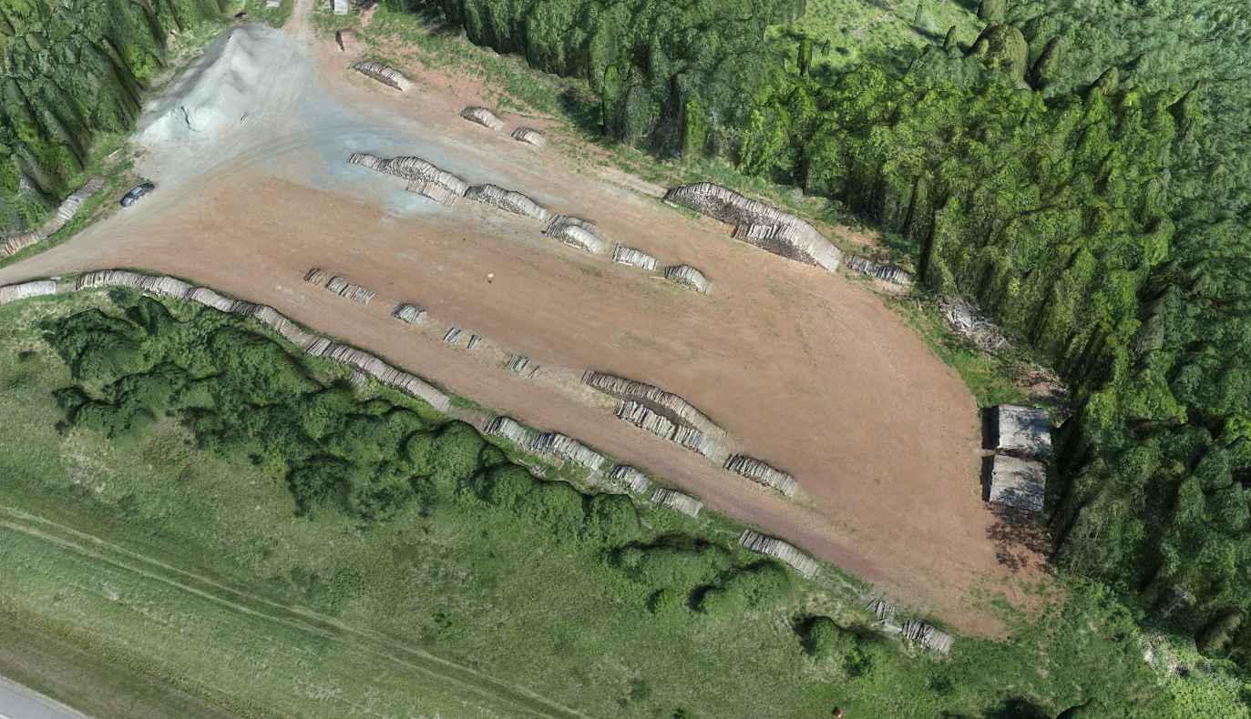
3d-modeling further enhances the relative height differences in a manner similar to elevation maps, while preserving the general character and true color of the features.
Inventory Assessment
Amazingly accurate volume measurements can be obtained quickly and at a fraction of the cost when compared to physical measurements. Large quantities of wood, mulch, gravel, or other materials can be inventoried at periodic intervals most beneficial to the client.Monitoring Timber Sales
Using a drone, we can get a comprehensive view of any timber sale in progress to ensure that things like slash distribution, leave tree designations, creek crossings, etc., are handled in the way it was prescribed in the contract. This is especially useful on very large timber sales or in hard to access places. We can then use those photos to quickly assist the operator in making needed adjustments.Regeneration Surveys
Large or remote tracts of young plantations can be quickly assessed for survival rates. Failed areas can be geo-referenced so replanting efforts are streamlined and efficient.Identify Insect and Disease Issues
Some insect and disease issues are most clearly seen from the air. Having an aerial view and the ability to geo-reference the affected area can assist in efficiently treating such issues.Assess Storm Damage
Time is of the essence when storms damage woodlands. If trees are not quickly harvested, they can become unsalvageable. Using the drone, we can quickly create maps that allow for accurate, timely treatment of the damaged timber.Education
Sometimes a picture truly is worth a thousand words. We use our drone images to help landowners understand what an actual harvest method will look like. This can be extremely helpful in the decision making process. For instance, the image below shows what we call a “Group Shelterwood” harvest, which are half acre circular clearcuts spaced about 225 feet apart.

Stunning Aerial Imagery and Videos
If you’ve ever wondered what your property looks like from the air, now you can know! Having aerial images of your property from multiple different angles, and at much closer distances than available elsewhere will provide a fresh, intimate perspective of your property, and even help you plan your next hunt! The videos can be paused, and the still images can be enlarged to allow for a closer look of areas of interest. Want a large wall map for the cabin or office? No problem. With Ruby, now you too can get a bird’s eye view!
Written by Stan Grossman & Beau Molitor.